
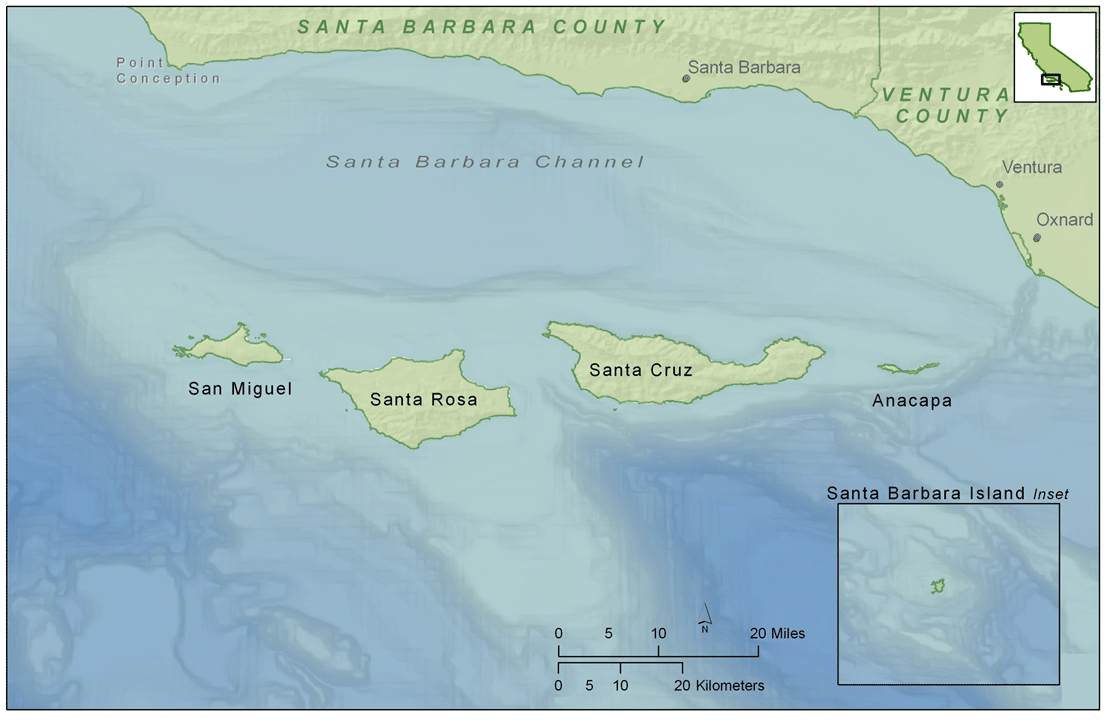
Channel Islands National Park: A Testimony Surrounded by Water
Visiting the Channel Islands off the coast of California is like taking a trip back in time. While breathing in the ocean breezes, observing the relatively untouched flora and fauna, and taking in the scenic coastal views, the island visitor can get a feel for what California was like during the days of the California missions and Mexican ranchos - a time before modern urbanization and development changed the State's landscape. This is largely due to the preservation efforts and formation of one of the newest national parks. Founded in 1980, the Channel Islands National Park is comprised of five islands located off of Southern California's Santa Barbara and Ventura coastlines. The islands are, from west to east, San Miguel, Santa Rosa, Santa Cruz, Anacapa, and Santa Barbara.
Not only do the Channel Islands provide an unique view of a relatively untouched California ecosystem, also evident in the park are three testimonies to truths taught in the Bible:
Come with us on a virtual trip to the Channel Islands.

Exploring Santa Rosa Island

Pier from the boat with Santa Cruz Island visible in the background.

The trip to and from the islands is part of the adventure!
Exploring Santa Rosa Island
Testimony #1: Pathways in the Sea
The ocean currents off the coast of California are a significant part of why there is such a huge difference between Northern and Southern California (and you thought it was due to people and politics!). Coming from the north is the California Current which is a cold current with relatively low salinity and high dissolved oxygen content. Arriving from the west is a warm and quite saline current known as the Central North Pacific Water (think Hawaii). Coming up from Mexico and hugging very close to the shoreline is the warm and shallow California Countercurrent and the deeper California Undercurrent. All of these currents collide and mix south of Point Conception in the Santa Barbara Channel where the Channel Islands are located.


The currents are what makes Southern California beaches so nice, warm, and enjoyable; and what makes Northern California beaches so cold and frigid. These currents also affect weather. Warm water produces and helps carry high energy and heavy rainfall producing storm events (e.g., the Pineapple Express); while the cold water off of the Northern California coast produces heavy fog banks and wind even during the summer months. One could argue somewhat successfully that the currents are the reason why people from Southern California are different from those in Northern California. The beach environment affects beach culture which in turn affects local culture. Hence, shave ice and the smell of coconut sunscreen in SoCal, and coffee and sourdough clam chowder bowls of NorCal.
Color gradient map showing the relative water temperatures due to the mixing of the three currents. Yellow indicates warmer water and dark blue indicates colder water. Greens and light blue are areas of mixing. Source: National Oceanic and Atmospheric Administration (NOAA)


While the extent of influence ocean currents have on California culture may be debatable, there is no denying that the various ocean currents entering and mixing in the Channel Islands National Park have given each island its own micro-climate and, thereby, has made each island unique in flora and fauna. This provides a visitor to the Channel Islands with a slightly different experience at each island they visit.

Anacapa, the smallest of the Channel Islands, located farthest to the east of the group of northern islands and in the warmer water, has little fresh water sources and is arid and exposed. Therefore, the vegetation tends to reflect this dry and rugged environment. This is contrasted with Santa Rosa, a large island located approximately 30 miles to the west of Anacapa, which has a more diverse blend of terrestrial vegetation. Because Santa Rosa is surrounded by colder waters from the California Current, it tends to have more fog, which allows other endemic plants such as the Torrey Pine and ferns to thrive on the island.
Plants on Santa Rosa island are more diverse and include some that need a wetter environment that is provided by regulare fog banks.
You have made him (man) to have dominion over the works of Your hands ... the fish of the sea that pass through the paths of the seas. Psalm 8

David, who wrote Psalm 8, most certainly did not spend much time traveling the world's oceans and probably did not understand the concept of ocean currents. But moved by the Holy Spirit in this great psalm of praise to God about His creation, David recognizes the role the Creator gave to humans, who were made "a little lower than the angels," to have dominion over animals, birds, and all that pass through "the paths of the seas." While David might not have comprehended the full truth of what he wrote and what eventually would become known as Psalm 8, the Holy Spirt did understand these concepts and would reveal them to another believer approximately 3,000 years later.
Matthew Fontaine Maury (1806 - 1873) was an American naval officer who initially served as a sailor and was later put in charge of the Depot of Charts and Instruments. He told his family that the text of Psalm 8 inspired him to investigate the "paths of the seas." Matthew studied log accounts from numerous ship captains and officers about observations of how adverse winds and drift currents affected their sailing vessels. This lead him to publishing the "Wind and Current Chart of North Atlantic" which helped ship captains to use the ocean currents and winds to their advantage and, thereby, greatly reduce the time needed for their ocean voyages. This and his subsequent published scientific works have earned him the title Father of Oceanography.
As noted by the psalmist, paths have been found in the sea. Let's take a look at three of them:
Paths in the Seas:
Surface Currents:
Currents could be considered the "freeways" of the oceans. As Matthew Maury observed, if you want to move fast and efficiently across an ocean you will need to find the flow of traffic. But not only do ships follow currents so do most other things that travel the paths of the seas including fish, whales, turtles, sea birds, plankton, nutrients, and trash. Each of the major oceans have a circular current that spin around a center (gyre).

Surface ocean current patterns. (Credit: David Bice © Penn State University)
The direction of the Earth's wind currents is caused by the Coriolis Force. According to the National Ocean and Atmospheric Administration (NOAA), "the Coriolis Effect makes things (like planes or currents of air) traveling long distances around the Earth appear to move at a curve as opposed to a straight line." Which means that in the Northern Hemisphere, low pressure systems spin counter clockwise and in the Southern Hemisphere they spin clockwise. However, when it comes to ocean water currents the opposite is true. In the Northern Hemisphere, ocean currents spin clockwise around a center gyre. In the Southern Hemisphere, the current rotation is counter clockwise. This is due to the Ekman transport principle which states that the net transport of a water within a water column is perpendicular and to the right of the prevailing wind direction. Therefore, in the Northern Hemisphere, if the prevailing wind direction is along the coastline in the direction of the equator, water will move away from the coast and will be replaced by deeper nutrient-rich water (upwelling). However, if, in the Northern Hemisphere, the prevailing wind direction is moving along the coastline away from the equator, it will push the ocean water towards the coast causing it to slightly pile up and resulting in downwelling. Upwelling and downwelling can also occur in the middle of the ocean. If two prevailing winds are moving in parallel but opposite directions, via Ekman transport it will push one column of water into another column of water going the opposite direction, the waters will converge and pile up a bit. This is also where downwelling will occur and result in a fairly stagnant and nutrient-poor area of the ocean. This is what forms the central gyres in each of the major oceans. However, at the equator, if two parallel winds are blowing in the same direction on both sides of the equator, they will push water away from the equator to the north and to the south effectively lowering the water level and allowing deeper nutrient-rich water to rise to the surface (upwelling).

Schematic diagram illustrating the concept of upwelling and downwelling
Credit: PennState, NASA, and AE Nieblas, CSIRO (Anne.Neiblas@utas.edu.au)
Biblical Application:
How does faith and science intersect when it comes to environmental problems? Which of the following would be a Biblically appropriate response to plastic in the oceans?
'Moreover it is required in stewards, that a man be found faithful.' 1 Corinthians 4:2
In Genesis 1:4, when God divided the light from darkness on the first day of creation, He presumably accomplished it by initiating the rotation of the newly created Earth. This not only allowed for daytime and nighttime, but it also caused the earth's winds to have a prevailing direction and set the earth's oceans in motion. The rotating Earth not only causes circular motion but also a mixing of deeper and shallow waters. Without a rotating Earth, it would not take long for the oceans to be turned into a stagnate, nutrient-depleted, and hypoxic (oxygen-deprived) body of water that would be inhospitable to the life forms that the Creator would be placing in them on Days 5 and 6 of the creation week.

Thermohaline Circulation - The Global Conveyor Belt:

The "Global Conveyor Belt" driven by temperature and salinity differences (or thermohaline mechanisms). Source: National Oceanic and Atmospheric Administration (NOAA) National Ocean Service
https://oceanservice.noaa.gov/education/tutorial_currents/05conveyor2.html
Upwelling:
According to NOAA, upwelling is when winds blow parallel to a coastline, it pushes away surface waters and causes the deeper water that is rich in nutrients to rise to the surface. These nutrients (nitrogen and phosphorus which come from dead sea creatures) are vital ingredients for the growth of marine plants, including phytoplankton. These phytoplankton are the foundation of the food web in the ocean. All other animal populations in and associated with the ocean depend upon it or on what consumes it. In fact, it is amazing to think about that the largest animal on earth (the blue whale) feeds upon the smallest animal in the ocean (phytoplankton).
Areas of coastal upwelling, such as those off the coast of California, are some of the most productive ecosystems in the world and support many of the world's most important fisheries. Although coastal upwelling regions account for only one percent of the ocean surface, they contribute roughly half of the world's commercial fish production.
Upwelling does not always occur year round, in the Channel Islands, it primarily occurs in the spring and summer months near the islands of San Miguel and Santa Rosa.
A difference in temperature, pressure, or chemical composition drives many of the processes that we observe in creation whether it involves processes we see in the universe, Earth's atmosphere, or even in our own bodies. It is also a main reason why ocean water is moving from one place to another. When there are differences in water temperature, salinity, and density, it causes water to sink or float - moving it from one place to another. This is referred to as "thermohaline circulation" (thermo meaning heat, and haline meaning salt) which drives ocean water around the world in what is often called the “global conveyor belt.” The conveyor belt begins on the surface of the ocean near the North Pole in the North Atlantic where it is chilled by arctic temperatures. It also gets saltier because when sea ice forms, the salt does not freeze and is left behind in the surrounding water. This makes the water denser and causes it to sink toward the ocean bottom. Surface water then moves in to replace the sinking water, thus creating a current. The cold deep water moves south past the equator and continues on between South America and Africa all the way to the Antarctica. At this point, the same thing happens that occurred at the North Pole; the shallow water cools, ice forms, and the more dense surface water once again sinks. As the deep dense water moves along the coast of Antarctica, it splits off at two different places and heads north into the Indian Ocean and the Pacific Ocean. These two sections that split off subsequently warm up and become less dense as they travel northward toward the equator. Because they become less dense, they rise to the surface (upwelling) bringing along with it bottom nutrients and water rich in carbon dioxide, which are the very things needed to fuel the food chain starting with the bottom of the food chain - phytoplankton. The warm risen water currents then loop back southward and westward to the South Atlantic, eventually returning to the North Atlantic, where the cycle begins again. It is estimated that it takes approximately 1,000 years for a quantity of water to travel the entire Global Conveyor Belt circuit.


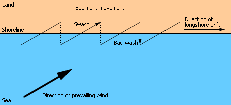
Longshore Currents:

Just as erosion on land surfaces is an hour glass marking time, so is the erosion and sediment transport along the ocean shorelines. If we look at rates of land erosion supplying sediment particles to water bodies and ultimately into the oceans, the rate of sediment transport in the oceans, and the rate that ocean sediment is deposited into sinks (places such as submarine canyons where the sediment cannot escape), it is difficult to justify an earth age of 4.5 billion years at a uniform rate of erosion. At some point, the erosion supply would run out and the sinks would fill up. It would require a catastrophic geologic "reshuffling of the deck" to start the process over. Genesis 6 - 8 records such a geologic catastrophe. It is strange that secular scientists who hold to uniformitarianism (things proceed as they always have proceeded), often fail to recognize the limitations of sediment supply, transport, and fate.
If you have spent any time in the water at the beach as a kid, you probably have had the startling experience of looking back to shore for your towel and umbrella and realizing that you have migrated a considerable distance down the beach without knowing it. You were the victim of a longshore current. But unsuspecting swimmers and boogie boarders are not the only ones that get moved down the beach. Most other things, including drift wood, trash, debris, small marine organisms, and sand particles are constantly on the move down the beach.
Testimony #2: Boundary for the Sea and Lifting up of the Islands
The above video is adapted from the National Park Service's Models of Change: The Geologic Story of Channel Islands National Park. However, the video has been altered for a Biblically consistent geologic interpretation. The NPS does not share this interpretation. To view the unaltered video, go to https://www.nps.gov/chis/learn/photosmultimedia/models-of-change-geology.htm
You might be surprised to learn that the Channel Islands did not always exist off the coast of California and they were not formed by volcanoes like the Hawaiian Islands. But what you might be very surprised to learn is that secular geologists and Biblical worldview geologists tend to agree on how they were formed with one area of disagreement - time! Both worldviews agree that the Channel Islands were formed along with what is today's Southern California geology by tectonic plate movement. While secular geologists calculate millions of years based on the current rate of tectonic plate movement, many Bible-believing geologists see a mechanism described in Genesis 6 - 8 for the rapid movement of tectonic plates that accomplished the same geologic work but in only one year!
This geologic work that shaped Southern and Baja California and formed the Channel Islands was the result of the heavier and denser Farallon Plate, located at the bottom of the ocean, crashing into the more buoyant North America Continental Tectonic Plate. As a result, the Farallon Plate subducted below the North American Plate causing the uplift of the Sierra Nevada range and volcanism. After the subduction and breakup of the Farallon Plate, the Pacific Plate moving in a northeast direction collided and sideswiped the North American Plate. This action is what gave Southern California its unique topography. The sideswiping essentially ripped Baja California off of the mainland of Mexico and caused a block of uplifted rock to rotate nearly 90 degrees forming the east-west transverse range which include the San Bernardino Mountains, the San Gabriel Mountains, and to the far west, a bit off shore, the Channel Islands.

'Behold, the nations are as a drop in a bucket, And are counted as the small dust on the scales; Look, He lifts up the isles as a very little thing.'
Isaiah 40:15

Video is adapted from the National Park Service's Models of Change: The Geologic Story of Channel Islands National Park. However, the video has been altered for a Biblically consistent geologic interpretation. The NPS does not share this interpretation. To view the unaltered video, go to https://www.nps.gov/chis/learn/photosmultimedia/models-of-change-geology.htm
The Genesis global flood and associated rapid tectonic plate movement, resulted in the warming of the world's oceans by extensive areas of mantle separation and subduction and volcanism that spewed significant amounts of ash and aerosols into the earth's atmosphere. This condition, in turn, created ideal conditions for the ice age to occur. As more of the earth's water was converted into a frozen solid mass deposited on land as glaciers and ice sheets, the ocean levels dropped dramatically. The United States Geologic Service believes that, during the ice age, the sea level was up to 400 feet lower than today's level. We can see God's sovereign plan in the ice age and lower sea levels to allow the post-flood re-population of the earth by humans and animals. (Refer to the third testimony from Channel Islands.) The lower sea levels provided in some cases land bridges that do not exist today such as from Asia to North America and provided ice free corridors of travel.
“Who kept the sea inside its boundaries as it burst from the womb, and as I [God] clothed it with clouds and wrapped it in thick darkness? “Where were you [Job] when I laid the foundations of the earth? Tell me, if you know so much. For I locked it behind barred gates, limiting its shores. I said, ‘This far and no farther will you come. Here your proud waves must stop!’ '
Job 38:4-6,8-11
There is much talk today of climate change and rising ocean levels as we observe more and more ice sheets and glaciers melting. After all, if the flood occurred 4,500 years ago and the ice age waxed and waned over the next approximately 700 years, it has, therefore, been only approximately 3,800 years since the end of the ice age. It is reasonable then to consider, from a Biblical point of view, that our climate is still moving into equilibrium from the effects of the global flood and subsequent ice age. How much more of the glacial ice and polar caps will disappear? It is hard to know. But observations over even our lifetime would indicate that the climate has not yet reached equilibrium. The ocean levels will most likely continue to rise. But we must remember that God ultimatley has control of the ocean levels and boundaries.
Testimony #3: The Populating of the Islands after the Genesis Flood


How did it arrive on the islands?
“Then God spoke to Noah, saying, “Go out of the ark, you and your wife, and your sons and your sons’ wives with you. Bring out with you every living thing of all flesh that is with you: birds and cattle and every creeping thing that creeps on the earth, so that they may abound on the earth, and be fruitful and multiply on the earth.” Genesis 8:15-17
After the Genesis Flood, how did the animals and humans re-populate the earth? Of course, to some places they could have just walked. But, what about islands, large and small, from Australia to Anacapa, how did plants, animals, and people arrive? Here are some possibilities ...

The ice age that followed the Genesis flood provided a mechanism for global transit. It lowered ocean levels that exposed land bridges such as Beringia that connected modern-day Siberia with modern-day Alaska. Ice free corridors on the North American continent facilitated over-land travel. Map source: Atlantipedia.
Walking to the Islands:
Although the ice age lowered sea levels as much as 400 feet, walking to the islands from the California mainland would still not have been feasible since the Santa Barbara basin is over 1,000 feet deep. There still would have been at least 3 to 4 miles of water between the mainland and the islands.

Floating to the Islands:
Swimming to the Islands:
If you were going to swim to the Channel Islands from Ventura, Oxnard, or Santa Barbara during the ice age would have been the ideal time because the distance would have been less. But, it would have still been a daunting task due to the strong currents that flow in the Santa Barbara Channel. Even in the late 1800's and early 1900's getting to the islands by a sailing ship or a steam-powered vessel was still a challenge and, during inclement weather, not even possible. Of course, stronger swimmers such as pinnipeds (seals and sea lions) would have no problem. For other mammals, such as foxes, pygmy mammoths, and skunks the task would have been formidable. We would have to wonder about the incentive for such animals to swim several miles in rough ocean waters.
In recent years we have seen the power of runoff caused by atmospheric river events that have pummeled Southern California. Even with engineered flood control facilities, stabilized and armored water channels, and weather prediction and modelling tools, significant damage is done by these modern storms. Post-Genesis flood weather patterns would have been even more intense and destructive due to warm oceans generating large and significant precipitation events. Without the modern flood control systems, debris flows would have been virtually unabated. Of course, just as it does today, most of the debris from high runoff events would be deposited on Southern California beaches. However, a small percentage would wash out to sea and a small percentage would also be deposited on the beaches of nearby islands. This is most likely how many species of plants found on the Channel Islands migrated from the main land to their present locations. It is quite likely that is how the Torrey Pine came to Santa Rosa Island. Pine cones of the Torrey Pine may have floated in the ocean from La Jolla in San Diego County to Santa Rosa via the California Countercurrent.

Pictured is a cone of the Torrey Pine - Could it have floated to Santa Rosa Island from La Jolla? Those are the only two places where the Torrey Pine is found. A subspecies is endemic to each location.

Floating debris from the Southern California mainland may have also had hitchhikers. This could explain how small non-flying insects, amphibians, and even vertebrates such as rodents arrived at the islands. The slender salamander, which is endemic to the Channel Islands, certainly could not have survived even a brief swim in the ocean. It must have been transported somehow. It is quite feasible for the salamanders to have been present on or in river debris washed from their riparian habitat.

Figure is from an article in Freshwater Biology titled Dispersal of aquatic and terrestrial organisms by waterbirds: A review of current knowledge and future priorities
Andy J. Green, Ádám Lovas-Kiss, Chevonne Reynolds, Esther Sebastián-González, Giliandro G. Silva, Casper H. A. van Leeuwen, David M. Wilkinson, published Jan. 31, 2023

Carried to the Islands:
Hundreds of years ago, the native island Chumash tribe traveled the Santa Barbara Channel for hunting, fishing, and trading. They built canoes, called tomols, from redwood trees that drifted down the coast, fastening the cut planks together with animal sinews and sealed with a tar-like substance called yop. Yop is a combination of pine pitch and asphaltum which occurs naturally in the Channel and along the coast from oil seeping into the water from below the earth’s surface. The tomol remains the oldest example of an ocean-going watercraft in North America. Just as later island setters brought supplies, equipment, and animals from the mainland, it is not hard to imagine that the Chumash also imported plants and animals (intentionally and unintentionally) to help them with their daily lives. Could the island fox have been brought as a pet? Wouldn't a pygmy mammoth have been a powerful resource to help with heavy lifting and construction of their villages. Plants that the Chumash valued on the mainland for their medicinal or nutritional benefits most certainly were imported and cultivated on the islands.
Information cited here about the Chumash is from the National Park Service.
Flying to the Islands:
Of course it is not difficult to imagine birds and flying insects migrating from the California mainland to the islands especially during the sometimes ferocious Santa Ana off-shore wind events. But things without wings may have also migrated to the islands by air. Seeds that propagate by wind may have been carried across the water during the Santa Ana wind events. Birds that eat seeds and fruit propagate the seeds unharmed in their excrement. If they fly to the islands after a meal on the mainland, the seeds will be deposited on the island inside a nice package of fertilizer (bird guano). Scientists are learning that birds transport more than just seeds. They can also carry live insects, water plants, snails, spores, bacteria, fish eggs, and pathogens. Invasive species can be introduced by birds. Is this natural propagation or a threat to the environment? Surprisingly a Biblical worldview will help answer that question.

The September 8, 2001, the Chumash Maritime Association constructed a 26-foot-long tomol which they named ‘Elye’wun in which was reenacted a historic crossing from the mainland to Santa Cruz Island. Photo credit: Robert Schwemmer/NOAA

In the 1800's and 1900's, cattle, sheep, goats, horses, donkeys, and pigs were brought to the Channel Islands by ranchers. Rabbits, chickens, game birds, bison, deer, and antelope were introduced for food and game. Cats and dogs came as pets and for pest control. And of course, there were non-intentional transportees including rats, mice, and insects.

Island Packers, the boat charter that ferries visitors to the Channel Islands, from time to time also shuttles non-human passengers to the islands. The California Department of Fish and Wildlife and National Park Service coordinated with Island Packers to bring this rehabilitated harbor seal back to its natural habitat.

The California harbor seal is a species of pinnipeds. The harbor seal is a rather small marine mammal, only getting up to five to six feet in length and 250 pounds. As with other seals, they are unable to rotate their pelvis, and so they drag their body inchworm fashion around on land, on beaches, or other nearshore rock ledges that have a low slope.

A joyful and healthy harbor seal returns to its native habitat thanks to some good Samaritans and a boat ride from the mainland.
Island Packers, the boat charter that ferries visitors to the Channel Islands, from time to time also shuttles non-human passengers to the islands. The California Department of Fish and Wildlife and National Park Service coordinated with Island Packers to bring this rehabilitated harbor seal back to its natural habitat.
Biologists and ecologists will refer to animals and plants as being native, endemic, non-native, or even invasive to a location. Species having the category native or endemic are highly regarded and epitomized as belonging to that ecosystem; while species with the classification of non-native or invasive are disregarded and many times actively eradicated. But have you ever stopped to think, that the islands at one time (approximately 4,500 years ago after the Genesis flood) had no vegetation or wildlife? So is it possible that what is referred to as non-native is just late to arrive and what is native is just the earlier arrivals?
Native or Indigenous
Native species of animals and plants within the Channel Islands include:
-
Western sea gull
-
Brown pelican
-
Bald eagle
-
California sea lion
-
California sea otter
-
Baja California tree frog
-
Southern alligator lizard
-
Townsend's big-eared bat
-
California sage brush
-
Coastal cholla cactus
-
Wild oats
-
California buttercup


Source: National Park Service

Source: National Park Service
Species of animals and plants that are typically found in a certain ecosystem are considered to be native or indigenous to that area. These animals and plants are naturally present in that ecosystem and were not introduced to that environment by outside human intervention (at least not in recent history). They are well suited to and thrive in their ecosystem. For example, deer and pine trees are native to the forests of the Western United States.
Endemic
Plants and animals that are unique to a location and not found anywhere else are considered to be endemic to that location. This can happen because the habitat in which they are currently found is the only remaining habitat because of development, climate change, natural disasters, or other mechanisms. Endemism can also be the result of population removal in other suitable habitats due to disease, eradication, overhunting / harvesting, or the arrival of a new predator or habitat competitor. However, in the case of islands, such as the Channel Islands, endemism occurs primarily due to isolation. A species of plant or animal will arrive to the islands due to one of the above-mentioned mechanisms and will become a part of the island ecosystem. However, as that animal or plant adapts to its new home and the stimuluses around it, the genetic information the Creator has placed in that organism will express itself in subtly different ways than it would have in another location having different stimuluses. After a few generations, this organism will develop physical traits that are unique to that location.
Endemic species of animals and plants within the Channel Islands include:
-
Island fox
-
Island spotted skunk
-
Island deer mouse
-
Channel Islands slender salamander
-
Island night lizard
-
Island scrub jay
-
Santa Cruz Island shoulderband snail
-
Santa Rosa Torrey pine
-
Island ironwood
-
Santa Cruz Island buckwheat


Source: National Park Service; (c) Bobstafford805 – some rights reserved (CC BY-NC)

Endemic to three Channel Islands: Santa Cruz, Santa Rosa, and Anacapa
Non-native
In reality, native and non-native can be subjective and ambiguous categories. For example, if you move to another location such as Northern California, at what point do you become a native of Northern California? In a year, 2 years, 10, 20, 30, 50, or 100 years? Or perhaps never. But if you have lived in one place for 20 plus years, I would think that most people around you would view you as a local or native to that location. Are honey bees native to California? Most people would answer yes. But, while there are bees native to California, the honeybee is a more recent import from Europe. However, from a Biblical worldview, the origin of all land animals can be traced back to Noah's ark and in obedience to God's command they spread out and propagated around the world after the flood. Some species of plants and animals happened to have arrived at certain locations earlier than others. So why are they natives and the late-comers non-natives? But wait long enough and the late-comers may become natives or, perhaps, even endemic. There is one thing true about plants and animals - they are on the move. They might not move quickly, but the move persistently, because that is the way God designed them and their design allows them to obey His command to fill the earth and to multiply. Animals move about in search for new homes, food sources, mates, to flee danger, or to migrate. Plants propagate through the dispersal of seeds, tendrils, roots, and being carried by water, wind, animals, or humans. Sometimes a species of plant or animal can find a new home and thrive and even take over. In such cases, it is referred to as an invasive species. Invasive species have been known to alter the balance in the ecosystem and out-compete other previous species. But if you stop and think about it Biblically, all plant and animals species on the Channel Islands were at one time non-natives. After the Genesis flood and associated movement of the tectonic plates, the Channel Islands were just bare outcroppings of rock and eroded sediment layers. At some point over the last 4,500 years, all the life forms we see today on the islands arrived – some earlier than others.
Species currently present at the Channel Islands that are considered to be non-natives and/or invasive include:
-
Eucalyptus trees
-
Star thistle
-
Sweet fennel
-
Feral pigs
-
Black rats
-
Argentine ants
-
Island foxes? Just because they came earlier are they natives or welcomed interlopers?
But 500 years from now, will they still be considered non-natives?

Source: National Park Service

Source: Channel Islands Restoration
Is the Island Fox native or non-native?
Source: National Park Service
The Bible tells us, that as believers in Jesus Christ, we are non-natives to this world. Like invasive species, we are to enter into an ecosystem that is foreign to us and make a difference with the gospel of peace. Hebrews 13:14 says, "For this world is not our permanent home; we are looking forward to a home yet to come." Just as animals and plants are obeying God's command by multiplying and filling the earth, so we must be obeying Christ's command to take the gospel into all "habitats" where humans are found. "And the Good News about the Kingdom will be preached throughout the whole world, so that all nations will hear it; and then the end will come." Matthew 24:14